


Slope Stability and Pipeline Foundation Assessment
Pipeline Foundation Assessment
Project Type: Slope stability and foundation-support assessment
Location: Western Canada
Client Need: The client required geotechnical input related to slope conditions, ground stability, and foundation support for infrastructure near potentially sensitive terrain.
AGATETEC Scope: AGATETEC reviewed slope geometry, visible ground conditions, drainage influences, potential instability indicators, and foundation-related geotechnical considerations.
Outcome / Engineering Value: The assessment supported early identification of slope and foundation risks and provided recommendations for risk reduction, monitoring, further investigation, or engineering analysis where required.
Engineer of AGATETEC was engaged to perform a geotechnical investigation and slope stability analysis for a proposed natural gas pipeline section near Chetwynd, BC, as part of a TC Energy infrastructure upgrade. The scope included foundation assessment for pipeline support, slope hazard evaluation, and recommendations for ground improvement or mitigation where required.
Test Pits: Excavated in accessible locations to assess shallow soil properties and verify stratigraphy.
Groundwater Monitoring: Standpipes installed to observe water table fluctuation and seepage patterns.
Topographic Survey: Conducted to develop accurate slope profiles and cross-sections for analysis. Slope Stability and Pipeline Foundation Assessment
AGATETEC provided geotechnical engineering support for slope stability and pipeline foundation assessment in areas affected by natural slopes, cut slopes, fill embankments, and utility right-of-way constraints. The work included review of subsurface conditions, soil strength parameters, groundwater and drainage conditions, slope geometry, pipeline support requirements, settlement potential, frost susceptibility, and erosion risk.
Slope stability analyses were completed using limit equilibrium methods, including Bishop’s Simplified Method and Spencer Method, where applicable. Soil parameters such as cohesion, friction angle, and unit weight were selected based on available laboratory testing, field observations, published correlations, and engineering judgment. Static, groundwater-influenced, and seismic loading conditions were considered as required by the project scope.
AGATETEC also reviewed pipeline foundation support conditions, including allowable bearing resistance, bedding requirements, subgrade support, differential settlement potential, frost-related movement, and drainage requirements. Recommendations included select granular bedding, non-frost-susceptible backfill where required, drainage improvements, erosion protection, slope-face stabilization, and monitoring options such as piezometers or inclinometers for higher-risk slope areas.
Where applicable, AGATETEC provided geotechnical input for retaining wall, MSE wall, and rockery wall concepts to support slope stabilization, grade transitions, and constructability. The work helped identify key geotechnical risks and provided practical recommendations to support safe design, construction planning, and long-term performance.

Slope Stability Assessment– AB:
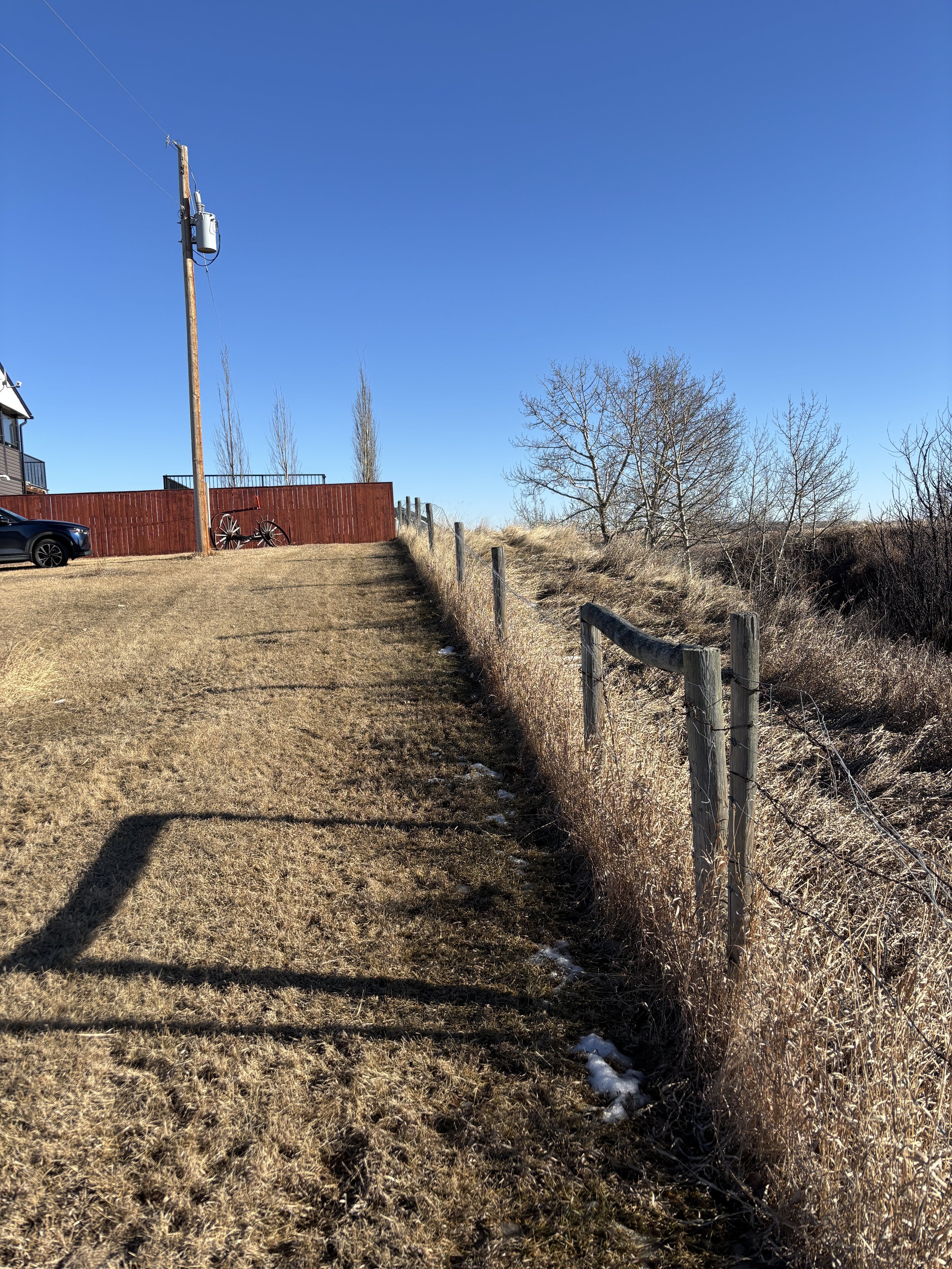
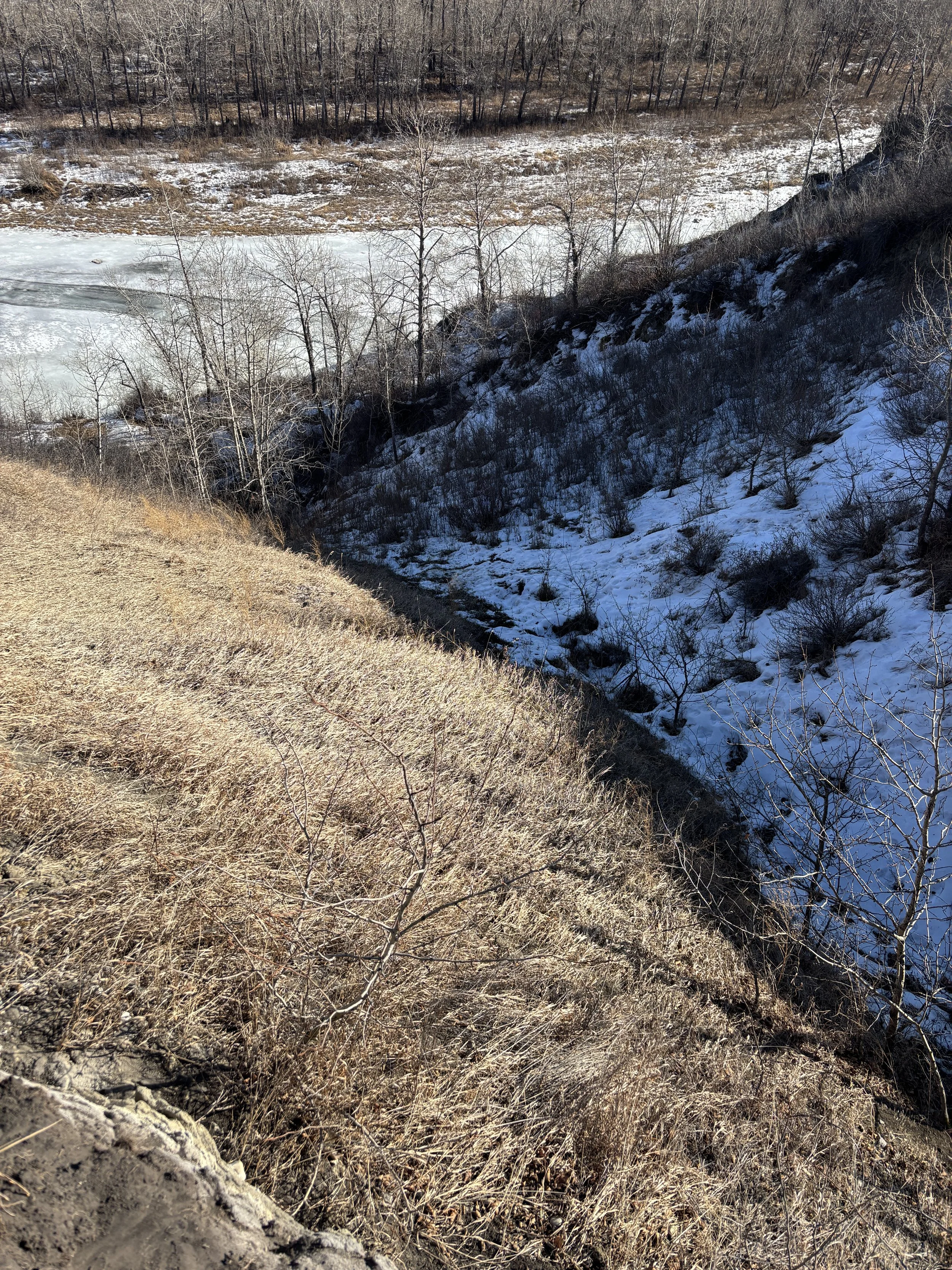
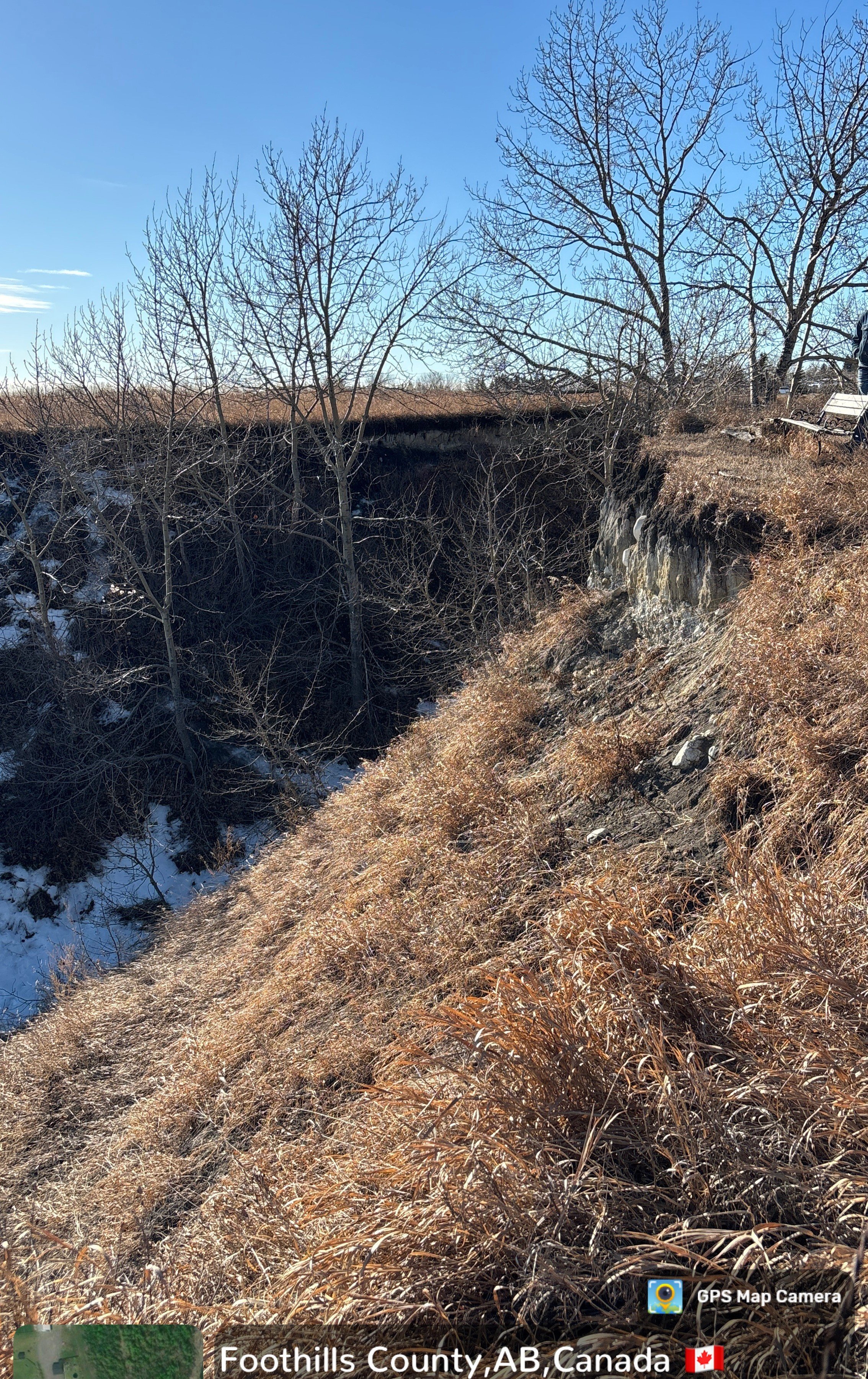
Slope Stability Assessment – South of Calgary, AB
AGATETEC Engineering completed a slope stability screening and visual geotechnical reconnaissance for a residential property located near a steep valley slope in south of Calgary, Alberta. The site included a residence positioned near a valley crest, with adjacent steep slopes, drainage pathways, vegetation-covered terrain, and evidence of localized erosion and exposed soil/rock faces.
The purpose of the assessment was to support development planning and provide the property owner with a practical understanding of potential geotechnical slope hazards. Our review included field observation of the crest area, slope face, drainage conditions, vegetation cover, signs of distress, and potential erosion features along the valley margin.
Based on the visual reconnaissance, AGATETEC provided geotechnical comments regarding slope setback considerations, erosion sensitivity, surface drainage control, and the need for further detailed investigation where future construction, grading, or loading near the slope crest is proposed.
Our Scope Included
Visual review of the slope crest, valley margin, and nearby residential area
Identification of visible slope instability indicators, including erosion, exposed faces, tension features, drainage paths, and vegetation conditions
Screening-level assessment of potential slope hazards affecting development planning
Practical geotechnical recommendations for setback, drainage control, monitoring, and future investigation requirements
Support for municipal development review and owner decision-making
Why This Matters
Properties located near coulees, river valleys, ravines, escarpments, and steep slopes can be affected by long-term erosion, seasonal moisture changes, frost action, toe erosion, and slope movement. Even when a slope appears stable at the surface, future development, drainage changes, landscaping, or added loads near the crest can increase geotechnical risk.
AGATETEC helps property owners, developers, builders, and municipalities understand these risks before construction decisions are made.
AGATETEC’s Approach
Our slope stability services are practical, defensible, and phased. For early-stage projects, we can begin with a desktop review and field reconnaissance to identify major geotechnical concerns. Where required, we can recommend additional investigation, survey, boreholes, instrumentation, and detailed slope stability modelling to support design and permitting.
This phased approach helps clients manage cost while making informed decisions. No guesswork circus. Just geotechnical due diligence with boots on the ground.